|
April 2001 Asian Dust Cloud |
 |
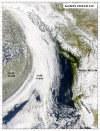
The atmospheric haze that was visible over northern California and the Pacific Northwest last Thursday and Friday (April 12-13, 2001) originated as a massive duststorm over the Gobi Desert a week previous. On April 6th a deep mid latitude cyclone was centered over northeastern Asia and entrained huge amounts of dust from the Gobi and surrounding areas (Figure 1). Note the streaks of light brown dust being entrained into the flow on the south side of low center. There is also a large amount of haze from anthropogenic sources visible over the Sea of Japan. This entrainment is seen and modeled on Doug Westphal's aerosol case study page from the Navy Research Laboratory in Monterey. This dust was transported across the Pacific at a latitude of about 40 degrees North at an altitude from 2-7 kilometeres (7,000 - 23,000 feet) and is visible behind a cold front that was approaching Vancouver Island on April 11th (Figure 2). Modeling of this event and other aerosols is done with NAAPS (Naval Aerosol, Analysis and Prediction System) using the Navy's NOGAPS model. The dust plume was seen on satellite imagery over the Great Lakes and then over the North Atlantic east of Boston on Saturday (April 14). |
|
Figure 1. (click to
enlarge) |
Figure 2. (click to
enlarge) |
|
Other Resources: |
|
Search
this Site
Questions, comments or suggestions. Email jan@ggweather.com
Copyright © 2000, Golden
Gate Weather Services.
Reproduction in full or part is prohibited without permission.