Narrative Description and
Station History
Miguel Miller, NWS
Jan Null, CCM
Golden Gate Weather Services

|
Climate of San Jose Narrative Description and Station History Miguel Miller, NWS Jan Null, CCM Golden Gate Weather Services |
|
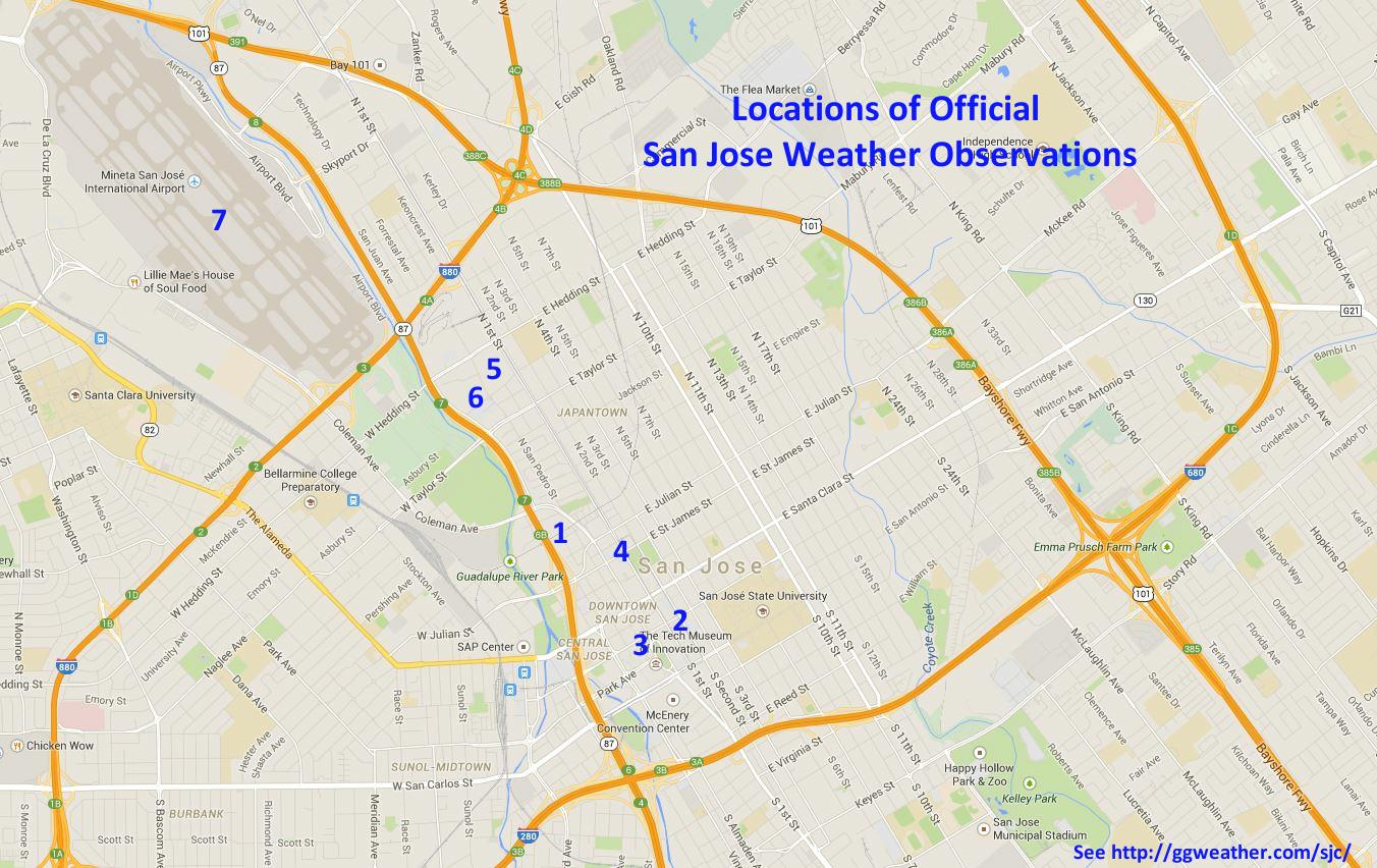
San Jose is located in the Santa Clara Valley which extends to the southeast from San Francisco Bay. The valley is oriented in a northwest-southeast direction with mountain ranges on both sides. To the west and south lie the Santa Cruz Mountains. The most prominent peaks in this range are south of the city and rise as high as 3791' on Loma Prieta. East of the valley lies the Diablo Range, including the famous Mt. Hamilton and Lick Observatory. The highest peak in this part of the range is Copernicus Peak at 4570'. Southern and eastern reaches of the city extend into the foothills of these ranges. Most of the city lies in the bay flats. Near Alviso the elevation is about 20 feet above sea level, the airport lies at 60 to 75 feet, and downtown about 90 feet. Outer edges of the city rising into the hills are higher than 300 feet. These areas are the upper sections of Alum Rock, Evergreen, Almaden Valley and Cambrian Park. There are several hills within the city. A group of hills just south of the Fairgrounds rise to over 400 feet. Some of the hills subdivide areas of the valley into smaller valley appendages. Most notably in the southern part of the city, the Santa Teresa Hills demarcate the Almaden Valley and rise to over 1000 feet. Climate San Jose's latitude and location on the west coast of North America place the city in a Mediterranean type climate. This classification is mainly identified by sharply contrasting wet and dry seasons. The wet season runs from November through March. 82% of the yearly precipitation total falls within this period. Rainfall is sparse from May through October. Rain during the summer months of June, July and August normally totals only 0.20". Wet seasons are cool, but mild. Dry season weather is very consistent, with warm sunny days. Coastal California experiences a marine dominated climate largely influenced by the cold California Current. During the dry season, a large and semipermanent high pressure area over the eastern Pacific establishes itself. This produces steady northwest winds parallel to the coast. These winds propel other physical forces which transport the surface water offshore. The surface water is replaced by the colder upwelling water. Strong upwelling during the summer and weak upwelling during the winter keep sea surface temperatures normally in the 50 to 60 degree range all year. Air coming in contact with the ocean surface is cooled and often condenses to form stratus clouds. The air near the surface cooled by the ocean waters contrasts sharply with the warm summer air aloft. This creates the stable Amarine inversion.@ The cool layer underneath the warm air is called the marine layer. Dry season weather is a combination of nocturnal low cloudiness, sunny days, and an afternoon sea breeze. The interior of California is heated by the hot summer sun, creating a thermally induced low pressure area. This creates a strong temperature (and pressure) contrast (gradient) from the coast inland. Cool air from the ocean moves inland with a strength proportional to the strength of the pressure gradient. This pressure gradient has been termed Aonshore flow.@ San Jose lies in a zone between true coastal influence and true inland influence. These influences are governed by the strength of the onshore flow. Onshore flow is the typical pattern during the dry season. Under neutral or offshore flow, the weather in San Jose has little marine influence. Summer weather includes nighttime low clouds to some extent for roughly two-thirds of the nights. In the presence of a strong and deep marine layer, clouds will develop during the evening and not clear until late morning. With a weaker marine layer, areal coverage of the nighttime clouds is often incomplete and random, or absent. Summer stratus clouds are almost never low enough to produce fog with visibilities that hamper transportation. Mid-summer high temperatures, assuming a weak to moderate onshore flow pattern, normally range from 80 to 85 degrees. Lows are consistently between 55 and 60. Afternoon high temperatures are tempered by the sea breeze off the bay. Offshore flow occurs when high pressure at the surface builds over the Great Basin province, with lower pressure off the coast. During offshore flow, all marine influence disappears, and temperatures can soar to 100 degrees or more during the dry season. These events occur during any season, but are most common in Fall, and secondarily in Spring. From Spring through Fall, dry warm air inland migrates westward. Additionally, this warm air is further heated by adiabatic compression as it descends the Diablo Range into the Santa Clara Valley. During winter, the air inland is not so dry and warm, so the warming effect is minimal. Dry season winds are nearly calm every day during the time period of an hour or two after sunset to around midday. Then, almost like clockwork, a northwest sea breeze of 10 to 15 knots will develop in the afternoon. Occasionally during the summer the pressure gradient is oriented from south to north, producing a southerly flow. The onshore flow then reaches San Jose through the Aback door@ through the southern part of the valley. Southeast sea breezes then develop, mainly in southern sections of the city. During wet season storms, strong southeast winds blow ahead of the cold front. Rainfall during the dry season is rare, but does happen as a result of late or early season storm fronts or southerly surges of subtropical moisture. These surges can occur when the late summer monsoonal flow over Arizona backs up into coastal California, or with the residue of a dying eastern Pacific tropical storm. Coastal drizzle, which can accumulate to measurable levels along the coast with a sufficiently deep marine layer, hardly ever amounts to more than a trace in San Jose. Temperatures during mid-winter are generally temperate with highs between 55 and 60 degrees during the day, and around 40 at night. Overnight low temperatures can vary widely during a calm, clear winter night. The bay flats are milder because of the modifying influence of the bay waters and the urban heat island effect near downtown. Wintertime lows in this area average between 40 and 45 degrees. Away from downtown or the bay waters are the slightly higher valleys of Almaden or the Evergreen area. Here, the modifying bay and urban influence is smaller, and lows average between 35 and 40 degrees. Radiation fog from the Central Valley advects into the Bay Area through the Carquinez Strait during wintertime offshore flow. It can also spill into the Fremont area over Sunol Pass from the Livermore Valley. Rarely, if ever, does this fog advect all the way to San Jose. Rather, radiation fog is more likely to form on its own, especially in sheltered pockets away from the bay such as the Almaden Valley, Evergreen, and Coyote Creek areas. Dense fog can develop overnight when the antecedent conditions include a moist lower layer (i.e. following a recent rain event), clear skies, and calm winds. Dense fog is not very common at San Jose International Airport, but it can have a great impact upon air transportation because of reduced visibilities. Winter storms normally occur due to occluded fronts moving into the region from the west northwest. The Pacific High moves southward as the westerlies of the Polar jet stream migrate southward into California latitudes. Occasionally, cold fronts from the Gulf of Alaska or warm rain events induced by an active subtropical jet, can produce significant rainfall. Thunderstorms are rare, but can occur in cold and unstable air masses following a cold front. Normally, the thunderstorms only produce brief heavy rainfall. Infrequently, they produce small hail or exhibit severe behavior such as a funnel cloud or very rare tornado. Rainfall during early spring and fall is infrequent. Most storms during this period produce light showers. However, polar and subtropical air masses can collide, producing very heavy rain events. External weather altering events, such as El Nino, can produce a significant increase to normal rainfall and extend the duration of the wet season. Two of the three wettest seasons of recorded history in San Jose were during strong El Nino events (1982-83 and 1997-98). The other season could have been an El Nino event as well, but it occurred in 1889-90, long before sufficient understanding of El Nino developed. San Jose lies in the rain shadow of the Santa Cruz Mountains. Air flowing over the mountains sinks upon reaching the valley, decreasing the necessary lifting mechanism for cloud formation and rainfall. Distribution of average annual rainfall over the San Jose area is largely dictated by topography, gradually decreasing from south to north. San Jose averages about one fourth of the rainfall received in the mountains. Contours of equal rainfall nearly parallel elevation contours. The 20" contour and foothill sections ring all but the northern part of the city in a tilted U shape. The 14" contour runs east-west along the northern part of the city, indicating rainfalls of less than 14" north of the airport. The annual rainfall within city limits ranges from about 13.5" near the bay, to about 24" in the southern extremities near Los Gatos. Snow is extremely rare in San Jose, with only a handful of well documented instances in over 100 years. Amounts are usually a trace and have never exceeded one inch. San Jose Station History Weather records for San Jose began in January 1874 when rainfall data were kept by the Southern Pacific Railway Co. At this time the railroads coming into California wanted weather records. In 1898, readings began at the Southern Pacific depot on Bassett Street. From May 1892 to September 1905, the records were kept by prominent local citizens A.C. Simonton, W.H. Hunt, E.P. Llewelyn, W.G. Taylor, and A. Bettens. In September of 1905 a full time Weather Bureau station was established in the old Daugherty building on South Second Street (near San Fernando Street). The earthquake and fire of April 18, 1906 destroyed the building and some of the weather records. On July 1, 1906 the U.S. Weather Bureau took over the station and re-established it in the Federal Building (now the San Jose Museum of Art) located at the corner of San Fernando and Market Streets. The station was equipped with more recording instruments and became a full service station. The depression years of the 1930s demanded cuts in some of its city services, and in 1933, the weather station was on the chopping block. However, the San Jose City Council, through the efforts of City Manager C.B. Goodwin, arranged to continue the work and assumed responsibility for the record-keeping. On August 5, 1933, the station was moved to City Hall on North First Street across from St. James Park, and Andrew B. Bennett became the record keeper. In 1939 the instruments were installed on the roof of City Hall after a year of comparative readings because the City Hall Park site was Abecoming increasingly undesirable.@ In November of 1940 Mr. Bennett resigned his position. Mae L. Bennett (relation unknown) then continued the record until May of 1943. In June of 1943 Ernest O. Billwiller of the San Jose Public Works became Director of the Municipal Weather Station, with assistance from fellow Public Works employees Ernest Walker and Leo Raiche. The station remained on the roof of City Hall until 1957 when it was moved to the new City Hall at 801 North First Street. Mr. Billwiller passed away in May 1964 and the services of he and his assistants were terminated the following September. Assistant Director of Civil Defense Russell Lunsford petitioned for locating the weather station at the Civil Defense Department because of the value of weather data to weather-related emergencies. With the support of the U.S. Weather Bureau and State Climatologist Robert Elford, the San Jose climate station was moved to the Civil Defense Department, its present site at 171 W. Mission Street. With the passing of Mr. Lunsford in June of 1965, the new Assistant Director of Civil Defense, Charles Rehling, assumed the responsibility of the weather station. From 1971 to March of 1992, Staff Technician Carol Sisemore served over 20 years as the cooperative observer. She served under the direction of Charles Rehling (1965-1977), and Emergency Services Coordinators Robert H. Black (1977 to 1991), and Dr. Frances Winslow (1991 to present). In March of 1992, Ms. Sisemore finished her work and handed the observing responsibility to OES Executive Secretary Robin Joseph, who keeps the record at the present time. On September 30, 2007 the official San Jose climatological station was colocated to San Jose Mineta International Airport and data was collected via the KSJC Automated Surface Observing Station. Station Locations
Acknowledgments: Special assistance provided by Jan Null, retired NWS forecaster, in
putting together and making sense of an enormous amount of weather data. Bibliography |
||||||||||||||||||||||||||||||||||||||||||||||||
Return to Climate of San Jose
Return to Golden Gate Weather Services
Copyright © 2015 Golden Gate Weather Services.
Reproduction in full or part is prohibited without permission.